Elizabethtown-Kitley Township
Greenbush
When we travel our township roads and see signs for places that have as few as two buildings left in that area, we wonder, why does it even have a name? We see little resemblance to a village or hamlet to justify the place name. They look like sleepy little places that time has passed by.
Greenbush is a village like so many others in our area. Time and modernization has changed it and it is no longer the industrious village it once was. Like many villages, its original name has even changed over the years. In its early development it was called Olds Corners. James Olds was not one the first to settle there but would be one the first to help create the village that was once one of the most thriving settlements in the back country. It is said that one of James Olds’ grandsons was Ransom E. Olds who started the Oldsmobile Company in 1896.
The first family that is known to have settled in the Greenbush area was John Saigon Blanchard and his wife Abigail Waite. They came from Salem, Massachusetts by way of Vermont in 1799 after it became the 14th State. They were Empire Loyalists, who supported the British government and came to Upper Canada with their infant son Amos to begin a new life under British reign. They came to Upper Canada with more than most Loyalists at the time, travelling by ox and cart with their personal belongings, ax, musket, adze, and blankets, carpentry tools and fishing gear. John was only 17 or 18 years old when he arrived to make a new life in the bush of Upper Canada. They were granted 200 acres in Elizabethtown Lot 28 on Concession 9. They were joined shortly after by John’s brother Aaron and wife Mabel Latimer Blanchard in 1800 who settled on 200 acres of Lot 28 Concession 8.
The land was rough and dense forest then. It is very hard for us sometimes to wrap our minds around what it was really like back then. There were no roads to anywhere only very rough trails if you were lucky. To find a lot in the back concessions would be like getting lost in a very rough thick forest and looking for a needle in a haystack for your property marker. To guarantee ownership of the land grant the grantee had to clear it and improve it for settlement. With very little tools and assistance, these new settlers had to start from scratch by cutting a clearing to build a house for their family as well as planting a garden and fields for food and livestock to support them. It was a hard life. The Blanchards were successful in their new beginning as the name is still prominent in the area.
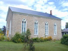
Another early settler to come to “Greenbush” was Rev. Sylvans Keeler, a travelling preacher also known as a “saddle bag preacher” or “circuit rider”. As a minister in the back country in those days, he spent more days away from home preaching as far away as Perth, which took two or three days travel to get there. Because of Rev. Keeler and his son John, “Greenbush” had help with their faith in the early days. In 1827 the Methodists started to build their own church with help from the surrounding area. John Keeler cut and supplied all of the stone for the church. They had great plans and ideas when they started to build a church to hold 500 people. It was to be 40 by 50 feet and was to be a copy of the early Methodist Church in Lyn. It took ten years to build and was not completed until 1837. The first Minister for the completed church was Ezra Healey.
1815 saw the Olds family settle in what would eventually be called Olds Corners. Like many towns and villages the first name didn’t always last. It is said John Blanchard gave the settlement the name of Greenbush after the place he came from in Massachusetts.
Moses Olds’ family, along with the Blanchard family, were the citizens that put Greenbush on the map in the back country. A village off the main road, far from any of the larger towns and cities, Greenbush in its first hundred years was very busy with small industries. The village had approximately sixty different people in the trades working in and around the village. According to an early census, Greenbush boasted a saw mill, two coopers, three stone masons, one cheese maker, one barber, four blacksmiths, one tailor, a flour mill, four carpenters, two carriage makers, two tanners, two shoe and boot makers, one sleigh maker and 6 store keepers. The village was never very big but it was very busy for its time and place.
Many of the families that called Greenbush their home town at the establishment of its settlement are family names still in the township. Blanchard, Olds, Moore, Gifford, Healey, Manhard, Hanna, White, Breton, Bolton and Salmon can still been seen on mailboxes in the area.
This is just a brief insight into Greenbush’s main streets. You can find out more in the Township Library in Spring Valley. Heritage Elizabethtown-Kitley produced a booklet, written in 1994, about Greenbush and Addison.
Jasper
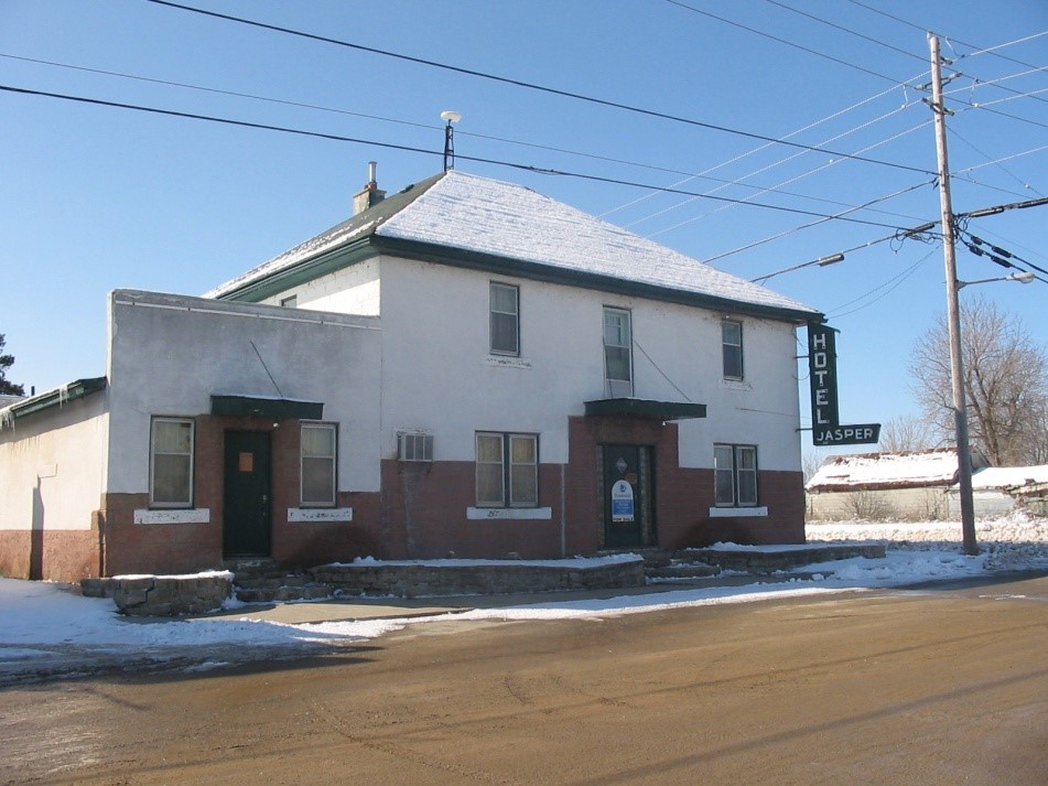
Heritage Canada The National Trust is encouraging Canadians to celebrate “Main Street: At the Heart of the Community”, for Heritage Week beginning February 16th, 2015. The streetscape of a main street can hint at the story of a town, but a main street need not be paved or even navigable by vehicles. Such a community is Jasper, Ontario. The hamlet straddles the boundary of not just Elizabethtown-Kitley but also of Leeds and Grenville. Sitting on the bank of Irish Creek, had the recommendation of a young Royal Engineer been heeded in 1816, Jasper would now be home to a portion the Rideau Canal, the most prominent of historic transportation routes.
In 1806 the first settler, a Mr. Haskins, came to what was then the old Johnstown district of Upper Canada. Along the banks of Irish Creek he built a grist mill and later constructed a saw mill. A decade later in 1816, following the War of 1812 and spurred on by concerns for defence, the government of the day was determined to find a secure route from the St. Lawrence to Bytown. A young Royal Engineer by the name of Joshua Jebb was employed to complete a survey of the Rideau route. Mr. Jebb did an exemplary job and mapped out two separate routes, the route of the Rideau Canal as we now know it and a second option. The second route, The Irish Creek route, was Mr. Jebb’s preferred route and would bypass the Rideau Lakes resulting in a shortcut of 20 miles. This route, heading south would have begun where Irish Creek joins the Rideau, south to Irish Lake, overland via a railway from Irish Lake to Upper Beverly Lake and on to Morton.
In 1826, six years after Gideon Olmstead purchased the mills from Mr. Haskins and the area had became known as Olmstead’s Mills, a second survey was completed of both the Rideau and Irish Lake routes by Samuel Clowes. The Irish Creek route required a total of 18 locks and a railway section to make it navigable and although it was the shorter of the two options, the increased cost determined the Irish Creek route was not viable.
By 1830 the construction of the Rideau Canal raised the water levels in Irish Creek and the destroyed the waterfalls that had powered the mills, resulting in their closure. Irish Creek was relegated into a waterway used for rafting timber from the interior and would never see the parade of luxury pleasure boats other Rideau communities now enjoy. Olmstead’s Mills remained unassuming for a further three decades.
The following thirty years saw the settlement being referred to more and more as Irish Creek, as mill operation on the creek was a thing of the past. The construction of the Brockville-Ottawa railway line brought new life to the area. On February 17th, 1859, a rail line was opened from Brockville to Smiths Falls that would continue on to Perth and then to Sand Lake, upstream from what was by then Ottawa. The railway was built primarily to serve the timber trade of the Ottawa Valley.
It was determined that a railway station be built at the mouth of Irish Creek and in 1861 the hamlet surrounding it became formally known as Irish Creek, when a post office was established. The railway with all its accompanying employment opportunities was an integral part of village life well into the next century. With the coming of the railroad, Ambrose Olmstead saw an opportunity and in 1862 hired a provincial land surveyor to map a community that spanned both sides of the railway tracks. This plan would see the small settlement of eight buildings, five in Wolford including a hotel, a store and the rail depot and three in Kitley that included a school house and two residences, grow into a village of twelve blocks and 95 village lots. Mr. Olmstead planned to change the name of the settlement from Irish Creek to Albune. The plan for the Wolford side of the village was registered in Grenville on the 6th day of August 1873 while the Kitley side was not registered with the Leeds county registry office until 1888.
The B&O railway officials were not impressed by the moniker “Irish Creek Station” and urged the residents to reconsider the name of the community. In 1864 the Post Office of Canada provided a list from which to choose another name and the name of “Jasper” was chosen, perhaps in preference to Albune. The name Irish Creek continued to be used and one of the 1st times the name of Jasper was formally used was in John Lovell’s 1871 Canadian Dominion Directory where he referenced both names. The Central Canada Directory of 1876 still referred to the village as Irish Creek.
The years following the coming of the railroad saw growth in the village. By 1873, Irish Creek, according to the City of Ottawa and Central Canada Directory of 1876 had a population of 50. Commerce was brisk and there was in place four general merchants, a milliner and dressmaker, two hotel keepers, two blacksmiths, a brick maker and a tinsmith. In 1875 a two room brick school house, the “Union School”, was built on the Kitley side of the village. The school, serving both Kitley and Wolford Townships was known as both SS. No. 22 Kitley and SS. No. 8 Wolford. The school house remains standing today and is now a private residence. The Jasper School is one of Elizabethtown-Kitley’s heritage designated properties. The village had two churches but on July 11th, 1920 the Episcopal Methodist Church, built in 1877, was destroyed after being hit by lightening. The United Church remained as the only church in Jasper and it has been deconsecrated and is now in private hands.
That Jasper grew into a thriving village during the last half of the 19th century and into the mid of the 20th was mostly in part to the presence of the railway. The Jasper station served all of Kitley and most of Wolford Township. Passenger trains disembarked passengers, some eager to consult with Mother Barnes, the “Witch of Plum Hollow”. Merrickville received their mail from the Jasper trains. The freight sheds emptied and filled daily, the livestock yards were busy. Hotels flourished, businesses grew. In 1894 Jasper had phone service, a decade before any other community in Kitley Township. By 1895, according to a Gazetteer of British North America the population of the village numbered 500. The Bank of Ottawa established a branch in the village at the turn of the century, although it remained no more than ten years. In June of 1914 a precursor of the Bank of Nova Scotia opened a branch in Jasper and in 1921 a cement block building was completed. The branch closed in 1939, the building is now a private home. In 1931, hydro came to the village.
As the Second World War raged in Europe, Jasper’s growth began to wane. The advantage of being a railway town was diminishing. It has been more than a half a century since a train made a stop in Jasper, the last being in 1961. The station itself was destroyed by fire in 1971. The last half of the 20th century, coming into the 21st saw the last remaining hotel closed, the general store was shuttered, Pryce’s Crown Assets store locked its doors for the last time, the annual Santa Claus parade is no more and mail is no longer picked up from the Post Master.
Irish Creek did not turn into a main street for watercraft; the VIA rail passenger trains still roar through the village and occasionally the different whistle of a freight can be heard, but, there are no passengers being greeted or freight to be loaded. Jasper is once again a sleepy little hamlet on the banks of a small creek with no typical main street, a hamlet the locals still refer to as “Irish Creek”.
Lyn
Lyn was founded by an enterprising man called Abel Coleman. It was his foresight, drive, and ingenuity in choosing this spot that made Coleman’s Corners the exciting place that it was.
Abel, a tanner by trade and his brother Richard, proceeded to look for a good spot for a mill. Abel Coleman built his first mill, cutting his millstone from the local granite.
As the town flourished, it was felt that a new name should be found. In 1837, the name Lowell was used after a town in Massachusetts where some of the early settlers had lived. It was found to be duplicated in Ontario, so the name Lyn was adopted as descriptive of the natural setting.
The first dwelling to be built at this time was a hotel. It is still standing at the corner of Main and Perth streets and the second house across the street built by Captain Stewart still stands.
In 1838 a new grist mill of much improved design was built. In 1841 a saw mill, a tannery for shoe leather, as well as a factory was added.
The Colemans expanded their enterprises. They had set up a saw mill, two leather factories that made uppers and sole leather. They rebuilt and improved the grist mill in 1859.
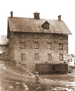
James Coleman put up what was the tallest mill in Eastern Ontario, rising five floors above the valley floor at Lyn. It is said that the original mill stone made in 1788 was incorporated into the front wall of the mill. This stone is presently mounted in the Centennial Gates entrance into the Douglas A Scott Jr. Memorial Park.
As time went on, other manufacturers were attracted to Lyn by reason of its water power and railway facilities. By 1871, listed in the Dominion Directory, the manufactures were: Bulloch Coleman—manufacturer of boot trees, crimps, pegs, dies, and decoy ducks, James Coleman—Harness maker, Erastus Cook—manufacturer, J. Cooper & Co.—sheepskin tannery, Ambrose Curtis—Miller, Horton & Taylor—Hub and spoke makers, Hover and Co.—Vulcanite rubber comb works, Lyn Flour & Grist Mills, George McLean—agent, George McNish—Iron Foundry, J. W. B. Rivers—Mill owner, Horace E. Rowe—Chinese Blood & Liver Syrups, William Thompson—Carriage maker, Henry Lee—Butcher , and S. B. Williame—Cheesemaker.
The first general store was operated by a druggist named Mr. A. T. Trickey. He manufactured two conditioning powders for horses and cattle which were reported to be “straight laxative”. A Mr. Gardiner bought the store in 1885. The old-time General Store was so much a part of village life as a place to visit and exchange gossip around the pickle barrel or pot-bellied stove.
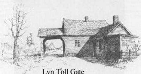
As one approached Lyn, there was a toll gate on what is now the Hudson’s Burnbrae Farm. Its design was much like others in the area. It was unpainted and well weathered to a dark brown. The door opened onto the road where there was a platform at the height of the axle of the wagon, so that the gate keeper would not step onto the ground. On paying the toll, the keeper raised the gate by an ingenious system of cogwheels and pulleys. The fee for one way was 3 cents and 5 cents return.
Skating on Lyn Pond and hockey with branches as sticks was a great delight to all ages in the early days. Dances and other entertainment took place regularly. The ladies wore lovely gowns made by the local seamstress. The local stores were well stocked with good fabrics and trimmings. The school house on Main Street provided a dance floor upstairs and a small stage for other entertainment. Some concerts and readings took place in the Pergau Block. This place was the telephone exchange as well as a small library, and cobbler and shoemaker — all run by the Pergau family.
Cheese has always been an essential source of nourishment in the pioneer diet. It is well known that there is no better cheddar cheese than that of Eastern Ontario. There were several cheese factories in and around Lyn. One stone building, still standing, is on the Howard Farm (on Howard / Centennial Road). It was one of the first. Matthew Howard was the cheesemaker and he milked forty cows daily. Two miles west of the village was the Union Cheese Factory which also produced good cheese. The cheese boxes and barrels were made in a small factory, still standing in the village. They sold for 9 cents but in 1965 they were $1.00.
The early settlers were keenly interested in the education of their children and no doubt, at first, there was the one room school house. The oldest is a lovely stone building built in 1867 located on Main Street. It was used for the “three R’s” as well as a concert hall. The classrooms were on the ground floor and the second floor boasted a small stage so that concerts and plays could take place. Parties and dances were held there too. It is now made into apartments for several families.
Hallecks School was used for over 100 years and was closed in 1963. A well was dug and a toilet installed in 1930. Before that, it was the pail and dipper and the out-house! In 1940, electricity was installed for the first time, and an expense sheet was found and it read: Seeley’s School, near North Star Farm, was used from 1889 to 1957. As the community of Seeley’s developed and grew, a school was necessary. One was built in Lillie’s School still stands though it is unused, is a good looking brick building. Howard School, has been unused as a school for years due to a tragic fire; it was refurbished and is now a fine family residence. Purvis Street School, west of Lyn, closed its doors in 1967.
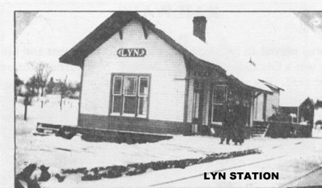
The Railway played an important role in the development life of the Lyn community. There was a Grand Trunk line (later the C.N.R.) from Montreal to Brockville from about 1855. Current information from the Canadian National Railways does not give the date of the line built from Brockville to Lyn. It was thought to have been in the 1850s but well might have been in 1880. The line known as the Brockville to Westport Railway was started in 1886 and completed in 1892. These two lines played a major part in the success of local industries. The B & W was in existence until 1952, a well-used line. Friday used to be cheese day and often as many as ten cars of cheese were brought to Brockville. Both railways had their own stations one (B & W) was near the pit on the Lyn Valley Road and the other was east of the stone house at the C.N.R. crossing on Lyn Valley Road. Both are gone today.
Religion played an important part in the life of the early pioneers. Most had had strong religious affiliations in their home-lands and a church was an essential part of their life. The earliest church seems to have been a small “log” church called Union or perhaps St. Paul’s, just east of the present St. John the Baptist Church. Various denominations used this facility. The Methodists seem to have been the first to build a church. In 1817 there were two Methodist churches in Lyn. The Episcopal Methodist church blew down in a severe storm and the present one, Wesleyan still stands which then became the St. Andrews Roman Catholic Church. The Presbyterian congregation got under way in the early 1800’s. A young recent graduate Mr. William Smart arrived in Elizabethtown in 1811. In 1875 long after he had retired from this congregation, he returned, to lay the corner stone of the newly constructed church. This site serves as the United Church today. In 1859, a site for an Anglican Church and rectory was obtained through the generosity of James Coleman.
Lyn Cemetery, one of Ontario’s oldest continuously used cemeteries, is located on the eastern outskirts of the village of Lyn. It was dedicated sometime around 1790. It is behind the St. John the Baptist Anglican Church on the south side — a portion of the old military road linking Kingston with Brockville via Yonge Mills and Lyn. Both the village and the cemetery are situated on the ledge of a gently rolling ridge overlooking a picturesque glen.
In 1912, a By-law passed by the Counties Council electing Lyn into a police village, (which was a form of municipal government used in the province of Ontario).
Lyn today is an active Village with many small family businesses. It has a strong sense of community and enjoys a variety of community events throughout the year from dinners to heritage festivals.
You can find out more about Lyn and the surrounding area by visiting the Heritage Place Museum in downtown Lyn.
Toledo
James Finch was granted the first patent of land, lot 22 concession 7, that would become part of the village of Toledo in February 1801. Land was granted on the condition of improving the lands for settlement. Finch’s property changed hands many times from 1801 to 1828. Charles May was granted lot 23 concession 7 in 1806 but quickly divided and sold it. This lot also passed through various hands. The north side of the present village was first sold to Truman Hicock and John Watson.
The Perth Road began in Brockville, today’s Perth Street and meandered through Elizabethtown–Kitley and on to Perth. This road was well travelled being the main thoroughfare for trade to the northern part of Leeds and Grenville and Lanark Counties. In the early days it was more like a trail than a road, a brutal journey for settlers and traders with steep hills and swamps to navigate. It was also an important route for supplies for the Rideau Canal during its construction. This road runs down through the village as County Road 1.
Wyatt Chamberlain has been credited with the development of the present day village. His first purchase was lot 22 Concession 7 and over the years he acquired most of the hamlet’s crossroad section along the Perth Road and County Road 8. Chamberlain was a prominent Methodist circuit minister when he arrived in Kitley Corners in 1833 due to an early retirement caused by a heath ailment. He built a general store and post office on the corner of the crossroads and is said to have built the first frame house. He was married to Catherine Halleck, daughter of Reverend William Halleck, a prominent citizen of Coleman’s Corners (Lyn) and had 13 children. By 1848 Chamberlain was selling village lots and Kitley Corners was becoming known as Chamberlain’s Corners. The name change may have has something to do with the sign over his store near the stagecoach stop and hotel. The village plan was officially drawn up in 1884 and the lots were irregular in shape due to Chamberlain’s lot development sales.
Chamberlain’s Corners was a bustling hub of activity by 1846. A major stop along the stagecoach route on the Perth Road, the hamlet had 40 residents, a store and a post office, and in 1850 William Robinson purchased property on the North side of the village and erected the Stage House Hotel. It was a grand structure in its day. In 1855 the village became the township’s municipal headquarters. A large two storey stone building was built. The ground floor contained offices, council chambers, a dining room and kitchen. The upstairs was a great hall. This room hosted many community functions such as dances and concerts. Social organizations were formed. The Methodists had held meetings in the hamlet since 1822. There was also a temperance league established there.
The hamlet continued to prosper and became the village of Toledo. Though the time and choice of name has not been determined, the main theory is that the post office was the trigger. Mailings came to the village as Chamberlain’s Corners, Kitley Corners or just Kitley which was also the name of the township. Toledo, Spain was also of major importance to British history during the war with France from 1793 to 1815 and one theory is the federal government at the time changed the name to Toledo through the postal system.
By 1859 the village was a busy industrial centre. It offered many businesses that catered to the village and surrounding area. There were 2 blacksmiths, a cooper, cobbler, tanner, woodworking shop, 2 hotels, 3 churches, 2 stores, 2 doctors, a temperance hall, town hall, cemetery and a schoolhouse. A tinsmith shop, butcher and bakery could be visited by 1881. By 1897 the village population had blossomed to 197.
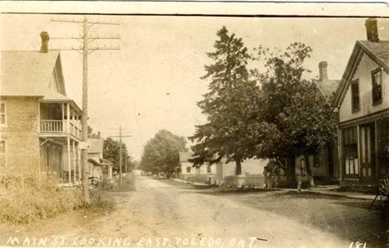
Toledo was a cultural centre at the turn of the 20th century. C. A Wood purchased lot 49 which was on the corner of King Street and Main Street. He opened a store. His son, Bert Wood continued with the mercantile business and expanded operations to include the office and switchboard for the Rural Telephone Company of Kitley. C. A Woods organised the first Toledo Brass Band. He also started a singing school at the town hall. Bert also continued this work and became a prominent and popular Toledo resident.
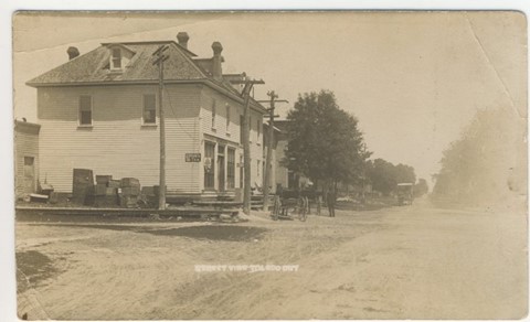
After the First World War, the Village Green in the heart of the village was born. The cenotaph was erected by local volunteers and a band stand was also located here. Many summer days were enjoyed by villagers and visitors who gathered to enjoy the music and socialize.
Though the population of Kitley began to decline as the automobile became the popular mode of transportation, Toledo stayed prosperous for quite a while. The Macadamising improvements to Highway #29 rerouted the traffic around Toledo and with modernizations we know today, Toledo became a quiet rural centre. The public school moved to Frankville and St. Joseph’s Catholic School was erected in the village. One locally famous furniture store, Struther’s of Toledo, brought many area customers for great service and excellent furniture. It closed its doors for good in the late 90s. Singleton’s Smithy still sports its golden facade and Woods store on the crossroads corner in the middle of the village is now an apartment building. Wyatt Chamberlain’s home has been recently renovated beside the Cenotaph. Toledo retains a strong community presence. The local churches are a community meeting place for worship and social gatherings like the Strawberry Social and the famous Fish Fry. The Toledo Legion holds dances, exercise classes and is the favourite spot for local wedding receptions in the area. Bellamy Park, on the outskirts of the village, is the summer home of campers from May to October as well as ball tournaments. County Road #1, part of the old Perth Road is still a short cut for transports heading to Perth and Highway #7.